Week 8.2: Maine, Part 2: The ReMaineder
Hey friends! We’re back with the rest of our trip through Maine, or as some prefer to call it, “The L.L. Bean State.” After parting company with the Browns, we headed up the coast towards Acadia National Park. Acadia is ridiculously photogenic, so brace yourself: a million photos are loading. We hope you have a decent internet speed.
The Road to Acadia
Before we get to the eye candy, let’s talk about the drive through Maine and RV driving routes. We quickly discovered on our trip that while we all know and love Google Maps, it isn’t that great for RV driving. Google always wants to send us down impossibly narrow or hilly roads instead of major highways, just to save about 16 seconds. It also has no mode or understanding of RV- (and truck-) specific problems like restricted roads, and once attempted to send us under a railroad bridge that would have sheared the top off of our motorhome. Luckily, we noticed the low height of the bridge in time, and were able to quickly change course. (If you’re curious, our RV is 11’6″, which is fine for almost all bridges.)

Losing the roof to our motorhome would obviously not be ideal, especially since that’s where the air conditioner lives. We frequently use an alternative app called RV Smart Route, which has a database of low bridges, restricted roadways, and even narrow or hilly roads, so it plots safe courses. Unfortunately, it doesn’t route around traffic, and it can sometimes be way too conservative – it will make you drive 2 hours out of the way to avoid 30 seconds of unpleasantness, for example. So if the RV route looks absurd, we’ll switch to Google Maps.
All of this is a lead-up to how we found ourselves ignoring RV Smart Route and listening to Google Maps on the way to Acadia, a decision which directly contributed to hurtling around narrow, twisting, mountainous 1-lane roads in the rain. In retrospect, maybe we should have taken the much safer recommended route – but hey, we saved sixteen seconds!

Acadia National Park
Acadia National Park has been one of the coolest places we’ve seen on our trip so far. Acadia is a huge park built on land donated by the Rockefellers, and it is like a ski resort for hiking and biking – there are trails everywhere, heading up some of the numerous small mountains or through pristine wilderness, and they all connect to each other. There is also a parkway which goes around the edge of the park, with beautiful vistas and picnic areas to pull off. We were confused by this at the time, but have since found quite a few “national parks” that are really just roads; it’s such a good thing America doesn’t have a problem with obesity.
We stayed on Mt. Desert Island, where Acadia is located, at Seawall Campground, which is on the very southern edge of the island. It is near an eponymous sea wall, which could be pretty except for the fact that it is almost always shrouded in fog. Of course, the only time the fog lifted was when we were headed somewhere else and had no time to stop. Ah well – at least we were able to take some album cover style pictures! Now we just need to figure out how to make an album…

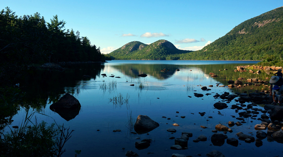
Acadia Loop Road
The weather was glorious for our first full day in Acadia, which we mostly spent driving around on the loop road and taking in all the sights. There are miles and miles of (extremely rocky) coastline, mountains, a nature center, a carriage house (?), and just so many pretty views. We took about 400 pictures, but Heather heroically narrowed them down to just the below gallery for your viewing pleasure.


Jordan Pond
After driving the loop road, we went hiking around the crazily picturesque Jordan Pond. Although the Jordan Pond hike is pretty flat, there was a long portion of it that was simply scrambling over rocks, maybe just for the challenge. The other portion of the hike required balancing on a narrow, raised wood platform, which was pretty simple, until you had to pass hikers coming from the other direction. Our athletic balance beam walking, combined with the sunny, warm weather, resulted in us being pretty sweaty when we finished the 3.3 mile hike, which is perfect because the end of the trail leads to a swanky restaurant.


Now, everything we ever saw about this restaurant, the Jordan Pond Tea House, indicated that there would be popovers and that we could eat them. So that was our plan: hike trail, eat popovers. Ingenious in its simplicity, really. Unfortunately, the popovers were a lie. Worse, the restaurant was way too fancy for the likes of us, and we and the other gross folks were shooed away to a gift shop selling trail mix and candy bars, and no popovers.
Whatever – we didn’t need your food anyway, Jordan Pond restaurant! (Except the trail mix and candy bars. We bought all of those immediately.) Jordan Pond pond, you were pretty, so we’re still bros.

The Beehive
On our second day, we decided to tackle the Beehive Trail, which is a moderate-level hike that goes up a mountain using iron rungs, ladders, and even a metal walkway. That was a pretty awesome hike! Unfortunately, it was insanely foggy, so the normally picturesque views looked like the inside of a cloud. Here’s what it could have looked like, courtesy of Flickr user tourtrophy:
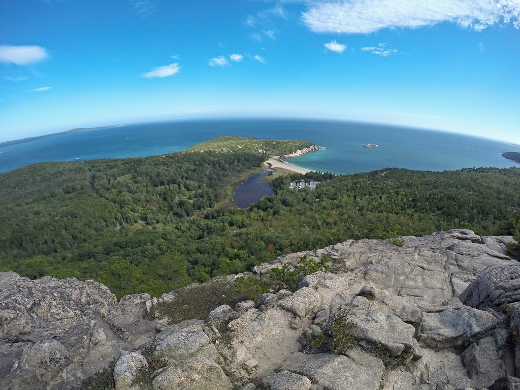
And here’s what it actually looked like:

At least we got some cool action shots (see gallery below). Incidentally, this all felt pretty badass at the time, until, at the top, we encountered people from the other direction coming down the trail with their dog. Bringing a dog backwards down the trail definitely seemed like a terrible idea to us given all the metal ladders and rails, but as we watched, the dog trotted past us, casually leaped down about 8 feet onto a narrow rock walkway without slowing down, and then just kept going, around the bend and out of sight. Well played, dog – THAT was badass.
The Beehive Trail at Acadia – leaving the path is not recommended! #acadia A photo posted by Jake and Heather (@nothingmundane) on


Miscellaneous Acadia Adventures
Included here for the sake of thoroughness, but these items don’t really deserve their own headings. They were subheading-level adventures, at best.
Bar Harbor The weather was awful again on our third and final day in Acadia, so we traveled into Bar Harbor, the town next to Acadia. Bar Harbor is a cute town, and we had the most incredible lobster bisque of our lives at a local gastropub, the Finback Alehouse. We’re still daydreaming about it. (Their blue label burger and clam chowder were pretty damn good too). We relaxed, drank some beers, and cranked out a blog post. (This one.) There are many worse ways to spend an afternoon.
A Crappy Lighthouse Bass Lighthouse near our campground seemed totally legit: it was marked on the map, had a big parking lot, and even had restroom facilities. But it turned out just to be a lighthouse. You can’t even go inside! All you can do there is walk up, say some version of “is this it?”, and then wander back to your car, slightly angrier than before.
The kind of day that lighthouses live for. #acadia
A photo posted by Jake and Heather (@nothingmundane) on
Cadillac Mountain
Cadillac Mountain is actually pretty great. Cadillac is the tallest point in the area, and you can drive or hike up for amazing sunsets. We drove up, and the view was great, and the sunset as glorious as advertised. Unfortunately, because we were taking photos directly into the sun, none of our pictures captured it as well as we’d hoped. Guess you’ll just have to trust us that this was cool.


Freeport
Acadia marked the easternmost point of our epic road trip. (The northernmost point was a Chipotle we stopped at in Bangor, Maine.) After Acadia, the “real” trip began, where we started traveling to a lot of different places, quickly. We were headed to New Hampshire next, so we stopped for the night in Freeport, Maine, home of the famous and inexplicably huge L.L. Bean Store, which Heather had never seen.
How to describe the Bean store? Well, first off, imagine a lot of flannel. No, no, MUCH more than that. No matter how much you love flannel, you do not love it as much as L.L. Bean does. Now add in ugly but functional winter boots, a mix of high-end camping and hunting, taxidermied animals, and a trout pond, and make it as big as 5 Wal-Marts. Then place it in a state so barren of people that the store itself becomes the most interesting thing within 100 miles.
The economics of all of this are highly questionable, but it seems to work for them. Oh, and there’s a rather large boot.

After paying our respects to the boot, we headed off to meet our friends Matt and Kate for some hiking in New Hampshire. Stay tuned.
Last Bits
What’s next: Currently, we are in San Antonio, Texas, hanging out with some friends and rehabbing Jake’s recently (and inexplicably) sprained knee. We’re headed west to El Paso, with stops currently scheduled for the Caverns at Sonora, Texas, the crazy art town of Marfa, and Big Bend National Park (knee permitting).
Obligatory social media self-promotion: If you want to follow along and you haven’t yet, please Like us on Facebook and/or follow us on Twitter (@NothingMundane) and/or Instagram (NothingMundane) to make sure you get all the updates. We are happy to report that doing so is now less likely than ever to result in placement on the no-fly list.
Shamefully missed a prior post? You can check them out below, as long as you feel appropriately guilty.
.
Next Post: Week 9: Old Friends, New Hampshire